

Mixed-use development has long been shortchanged by conventional traffic analysis. Conventional trip generation methods often treat each land use in isolation, using data collected mostly in auto-oriented suburban contexts. The result is that analyses can overstate vehicle traffic and understate how much people walk, bike, and take transit in mixed-use neighborhoods with strong connectivity, walkability, and transit service. This can lead to real downstream impacts, including oversized transportation infrastructure, higher development costs, inflated vehicle miles traveled (VMT), and skewed public perceptions.
MXD was built to fix that—and we’ve just released its most significant update since the tool was first developed over a decade ago.
The 2026 update draws on new academic research covering 622 mixed-use sites across over 30 metro areas nationwide, a substantial expansion from the original dataset of 239 sites across six metros. It also integrates trip generation rates from the ITE Trip Generation Manual, 12th Edition, released in 2025. To evaluate performance under today’s travel patterns, we collected our own independent post-COVID trip counts at more than 25 mixed-use sites across every Fehr & Peers market region. Results show that MXD performs more consistently than conventional approaches and better reflects how people are traveling in mixed-use settings.

Click to expand.

The update also reinforces something we have seen in practice for years: travel behavior varies by place and setting. The latest MXD is ready to be used anywhere in the United States, and it is designed to be customized and enhanced for communities based on local development patterns and transportation systems.
If you are working on a mixed-use project or are interested in developing a customized version of MXD for your community, we would be glad to discuss whether the updated MXD is the right fit.
share this article
Connect with Our Contributors

John Gard
Principal
AICP, PTP
Email Me

Mackenzie Watten
Travel Behavior Practice Leader
Email Me

Gillian Zhao
Planner
Email Me
Explore More
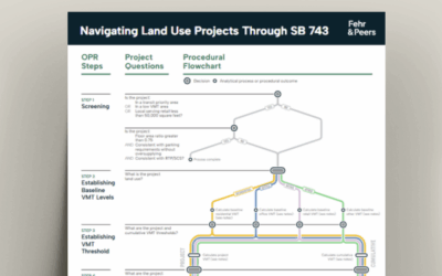
Navigating Land Use Projects Through SB 743
This document offers a step-by-step framework for evaluating and mitigating VMT impacts of land use projects under California’s SB 743 guidelines.

Fehr & Peers Tacoma Opens its Doors
Our new Tacoma office will allow us to continue to grow, better serving our existing and new clients, and giving our staff the opportunity to call the South Sound home.
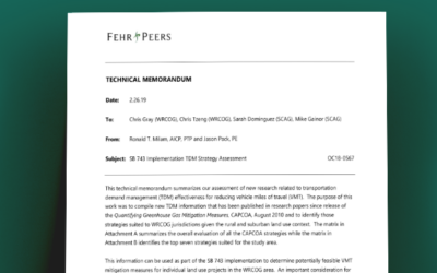
TDM Strategies Technical Memorandum
This information can be used as part of the SB 743 implementation to determine potentially feasible VMT mitigation measures for individual land use projects in the WRCOG area.