
Rethinking Street Design for Safety and Emergency Access

Rethinking Street Design for Safety and Emergency Access
Cities want neighborhood streets that are safe, livable, and ready for emergencies. But in practice, those priorities don’t always align. Rigid standards and siloed decision-making can push communities toward wider streets that increase speeds, raise long-term costs, and limit space for housing and neighborhood amenities.
This February 2026 ITE Journal article, “Safer Streets Through Abundance: Aligning Fire Codes, Safety, and Community Goals,” looks at a different path forward: connected street networks that give emergency responders multiple routes, and early collaboration between fire, transportation, planning, and public health teams.
When departments work together from the start, communities can move beyond one-size-fits-all standards and design residential streets that support both emergency response and everyday safety.
Contact us to explore how your community can balance emergency access with safer, more sustainable neighborhood design.
share this article
Contributor

Matt Goyne
Principal
Email Me
Explore More
Metro Emerging Trends Study
Utilizing the TrendLab+ scenario planning tool, the study assesses the short- and long-term impacts of these trends on vehicle miles traveled (VMT), transit usage, safety, and equity within the Portland region, providing insights to inform the 2023 Regional Transportation Plan update.

Applications of Big Data in Safety Analysis
Check out the new ITE brief written for transportation professionals to determine the most effective data sources to apply when scoping, implementing, and evaluating safety projects.
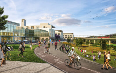
Reclaiming a Concrete Desert
Learn how the once-touted largest single surface parking lot, now known as SDSU Mission Valley, is being reimagined. The new design is all about reducing the need for cars, improving mobility, and creating a vibrant, walkable, and bikeable environment for the local community to enjoy.