10% RULE
Referring to a collection of counts for only one, or occasionally two, weekdays to represent typical weekday traffic volumes for an area. The presumption is that one to two days of counts would generally fall within +/-10% of the typical weekday volume[1]. While this rule is a common accepted standard practice, it is rarely validated due to the high costs of additional data collection and ignores the land use and transportation network context of the count site.
30TH HIGHEST HOUR
Referring to the 30th highest hour of annual roadway volumes,[2] presumed in urban areas to occur during the typical weekday commute period of 4-7 PM with 5-6 PM as a common default. Roadways and intersections are designed to accommodate this hourly volume based on the goal of balancing cost, use, and driver expectations, making it important to understand potential volume variation.
Recognizing that most jurisdictions will not have this type of data set, we also acquired a large sample of turning movement volume estimates from StreetLight Data for several of the same intersections. If having larger multi-day data sets proves advantageous, then practitioners need a cost-effective method for collecting that data. To increase confidence in the use of StreetLight’s estimates, Fehr & Peers also relied on the City’s database to directly compare and statistically validate StreetLight’s turning movement volume estimates.
In this first blog post in a series on traffic volume estimation and StreetLight validation, we examine key questions to understand the possible variations for each of the industry standard methods noted above.
Daily Traffic Variation
| Average Daily Traffic Volume | Number of Intersections | Total Days +/- 10% |
|---|---|---|
| 5K - 15K | 17 | 80% |
| 15K - 30K | 32 | 88% |
| 30K - 50K | 31 | 91% |
| 50K - 100K | 27 | 88% |
| 5K - 100K | 107 | 88% Overall |
The 10% Rule
Do peak hour volumes only vary by 10% or less?
What is the risk of under- or over-estimating typical volume when using one- or two-day counts?
This table uses the City of Roseville’s observed data to examine the percentage of days within +/-10% of the mean for each intersection, based on the total daily volume.
The daily Total Entering Volume (TEV) data shows that generally, for larger intersections, about 10-12% of days fell outside of the standard 10% range from the mean. However, for intersections with a daily TEV less than 15,000, like residential, school, or outlying areas, this number jumps to 20% of days outside of the 10% range. This means that one- or two-day counts are not accounting for the year’s traffic variations: 10-20% (equivalent to 36-73 weekdays in the year) are not being represented accurately.
Common traffic data fluctuation factors may include nearby collisions, construction, weather, special events, school traffic, seasonal recreation, and/or variable congestion on parallel or intersecting facilities (including the effects on traffic routing results from apps such as Waze or Google Maps).
Hourly Traffic Variation
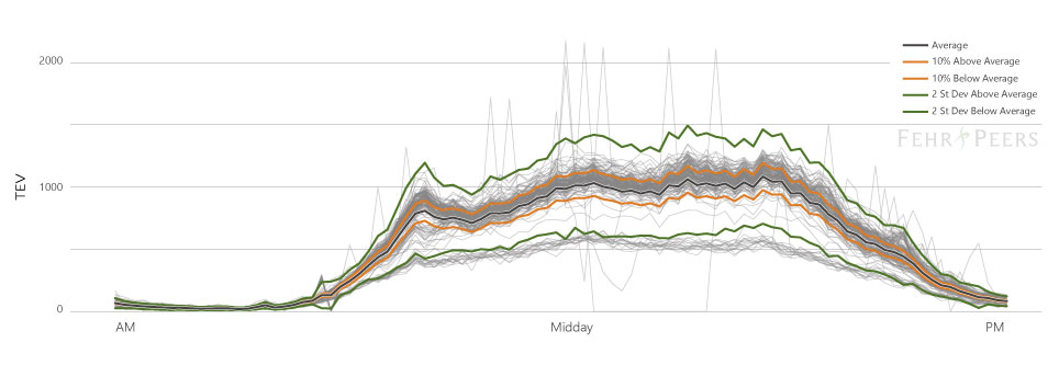
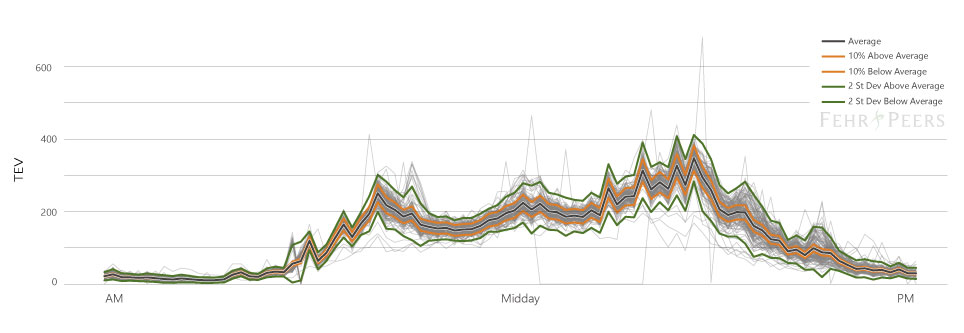
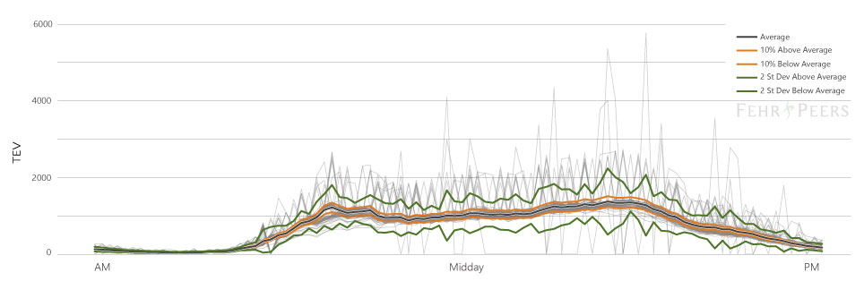
The charts below show 256 weekdays of volume across an entire day (in light grey) and indicate where the +/- 10% range falls in comparison to the standard deviation of the data at an hourly level. We presume that one standard deviation captures about 68% of data (the range between the green lines). So, when the orange 10% lines fall inside of the one standard deviation line, the typical +/- 10% rule-of-thumb approaches a 50/50 chance of being wrong at the hourly level. These four case studies illustrate the 10% rule failing during peak hours, where peak hour counts from a single day of data collection would only represent an average weekday about 50% of the time.
Stanford Ranch Boulevard/Five Star Boulevard
Adjacent to State Route 65 ramps, this intersection experiences a significant portion of regional shopping traffic to/from a large mall and other nearby retail establishments.
Atlantic Street/Interstate 80 WB On-Ramp
This intersection is heavily influenced by commuter traffic accessing I-80 and freeway conditions that cause backups onto the ramp from Atlantic Street.
The 30th Highest Hour
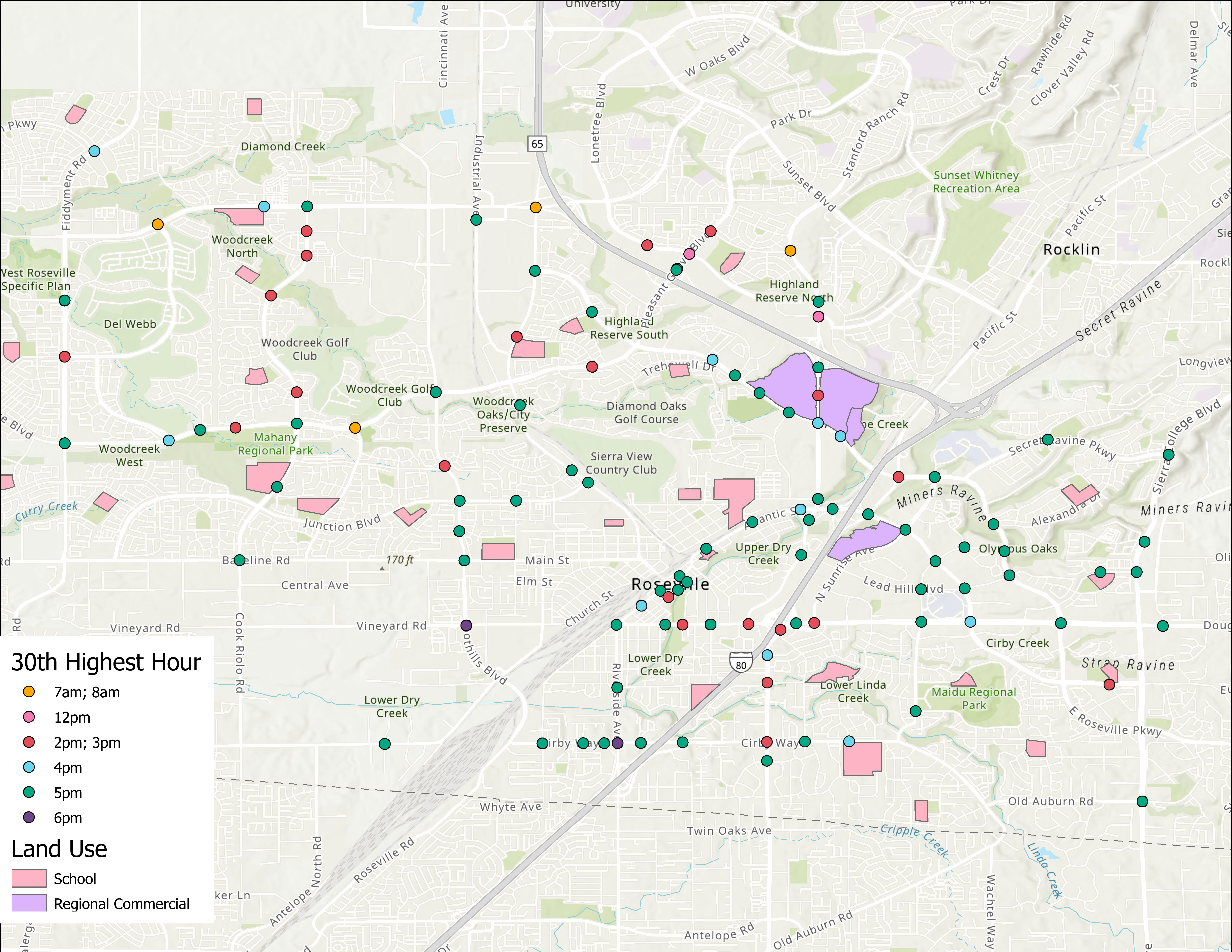
Which hours represent the 30th highest hour of intersection volumes?
Schools generate peak travel between 2-4 PM in the study area and their presence shifted the 30th highest hour to this period in multiple cases. Congested conditions caused a different type of shift. Major arterial intersections near interchanges also had 30th highest volumes in the 2-4 PM window, but a review of congested speeds revealed that not all the 5-6 PM volume was likely counted. At congested intersections, the counts only captured the vehicles making it through the intersection and not the ones stuck in queue. Consequently, more vehicles were observed moving through these intersections during the 2-4 PM period, when queueing was not as severe, than were observed during the 5-6 PM period.
What Does This Mean for Practitioners?
The evidence above supports the hypothesis that larger traffic count data sets are needed to adequately estimate peak hour volumes for intersection and roadway analysis especially in congested areas and near unique land uses such as schools and major shopping centers. This raises the question of how to obtain that data cost effectively and within a reasonable schedule. To help answer that question, we are evaluating StreetLight’s turning movement volume estimates. The evaluation consists of statistical validation tests for how well StreetLight’s estimates match the observed intersection volumes from the large Roseville sample to support how the practice can evolve to use better data sources in the decision-making process.
[1] https://www.fhwa.dot.gov/policyinformation/tmguide/tmg_fhwa_pl_17_003.pdf
[2] A Policy on Geometric Design of Highways and Streets¸ American Association of State Highway and Transportation Officials, 7th Edition, 2018 (AASHTO Green Book)
[3] A Policy on Geometric Design of Highways and Streets¸ American Association of State Highway and Transportation Officials, 7th Edition, 2018, Page 2-17.
share this article
Explore More
Focusing on VMT Metrics Through a Microscope
Understanding Post-Pandemic Travel
Clients often ask how travel behavior has shifted since COVID-19. Our self-funded study reveals significant changes, especially at office buildings. These findings could shape future transportation planning. Read the full white paper here.
Fast-Tracking Multimodal Analysis
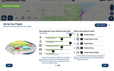
Learn about this first-of-its-kind web application that streamlines the design and evaluation of complete streets, allowing users to build and evaluate street cross-sections in real time.

