
Prioritizing People in Multimodal Design

Prioritizing People in Multimodal Design
Communities are starting to shift transportation planning, from practices previously concentrated on vehicle mobility, to focus more on accommodating people. More specifically, cities are putting people first when designing streets and intersections. This also helps to better meet the needs of rising micromobility options, dining and entertainment space, and the continued use of ridesharing services.
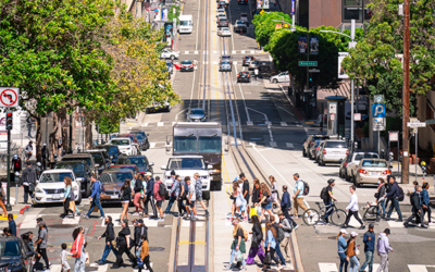
Salt Lake City is one such city working to revamp and transform their public streets. In a recent partnership with Salt Lake City and Gehl Studios, we developed the Salt Lake City Street and Intersection Typologies Design Guide. Many streets throughout the state of Utah, and specifically Salt Lake City, were originally designed to be wide enough for pioneer settlers to turn around a team of oxen. While times have changed from bovine forms of transportation, many streets have yet to be adapted to a new non-oxen reality.

Aerial view of downtown Salt Lake City
Rethinking Street Design
Redesigning streets to better accommodate people walking, dining, relaxing, or other pleasant activities, can result in improved safety and social, physical, and mental health. Such accommodations might include lowering vehicle speeds, significantly widening pedestrian zones, reducing the width and amount of travel lanes, adding trees, and incorporating other aspects to complement local businesses, public areas, and land uses.
There are key questions to consider when redesigning streets citywide. For example: Do residents desire walkable, leisurely spaces, or is transit the most important consideration? What existing features should be maintained- or enhanced through the redesign? What should the public right-of-way be used for in different types of places throughout the city?

Example of two-way thoroughfare
Source: SLC Transportation
Prioritizing and Defining Design: Putting People First
Salt Lake City wanted to make sure that all decisions were informed by their residents. The goal was to partner, listen, and connect with a variety of stakeholders through extensive research and community involvement, to paint a clearer picture of their community’s top needs and desires in different areas. Ultimately, the community was looking to put the oversized streets on a “road diet” to slim them down, and make the most of the extra space. This feedback made it possible to identify five primary categories for determining which uses of the right-of-way would be prioritized to best support land uses. These categories include the following:
- Person Mobility: sidewalks and bikelanes
- Greening: landscaping
- Placemaking: destinations
- Curbside Uses: pickup/drop-off
- Vehicle Mobility: travel/turn lanes
In order to communicate the effects of these priorities, the following rankings were created to indicate the city’s place types and the types of transportation changes associated with them.


Producing a Style Guide for Street Design
With clear priorities in place, guidelines for 17 street typologies and 9 intersection typologies were developed to update the look and feel of streets in Salt Lake City, and transform visions and values into a reality. The designs themselves can be adapted to other areas and streets to better align with community-specific priorities and so too can the process for developing new intersection typologies to retrofit any combination of streets.

Salt Lake City will integrate the Guide into their administrative process and possibly in their upcoming Transportation Master Plan. They are already using it to guide design projects on specific corridors, and to shape transportation and land use plans in different neighborhoods.
Interested in conducting a similar prioritization process or developing a typology design guide for your community?
share this article
Explore More
Driving Less Starts with Building Differently
How much can planning decisions actually reduce driving? Our latest research introduces a statistical model that links built environment choices—such as density, transit service, walkability, and land use mix—to vehicle miles traveled (VMT). The findings give planners and policymakers practical, evidence-based tools to evaluate scenarios, understand tradeoffs, and make more informed transportation and land use decisions.
Navigating VMT Under CEQA
VMT under CEQA continues to evolve as agencies, practitioners, and decision makers work through analysis methods, mitigation feasibility, and defensible evidence. Our new Q&A resource offers practical answers on vehicle miles traveled, SB 743, mitigation program design, implementation, administration, and legal and strategic considerations.
Demand Management Is Injury Prevention
New research shows that reducing driving exposure may be one of the most powerful safety strategies available. The findings connect VMT, mode share, and travel time to fatality rates, reframing demand management as injury prevention.