
Pedestrian Crossings
Understanding the evolution of crossing treatments, guidance, and travel behavior and their impact on pedestrian interaction with the built environment is critical to addressing quality of life challenges and meeting expectations for those who walk. The 2016 US Department of Transportation annual statistics for fatal traffic crashes revealed:
lives were lost on US roads in 2016 - a 5.6% increase from 2015.
%
of serious crashes are linked to human choices. These are not “accidents."
%
or more fatalities were caused by drunk driving and/or speeding.
of lives lost were pedestrians. The most since 1990.
Total fatalities continue to rise. On average, 14 pedestrians are killed each day and roadway deaths are a leading cause of death for children, adults between the ages of 18 and 35, and the elderly. Although the national story is not encouraging, local stakeholders in cities like Sacramento, California and Brighton, Colorado are identifying areas with critical pedestrian safety concerns to enhance infrastructure and save lives. Doing so is creating safer, more welcoming environments that facilitate economic vitality, healthy habits, and improved quality of life for those who walk by choice or necessity.
Planning for Your Agency
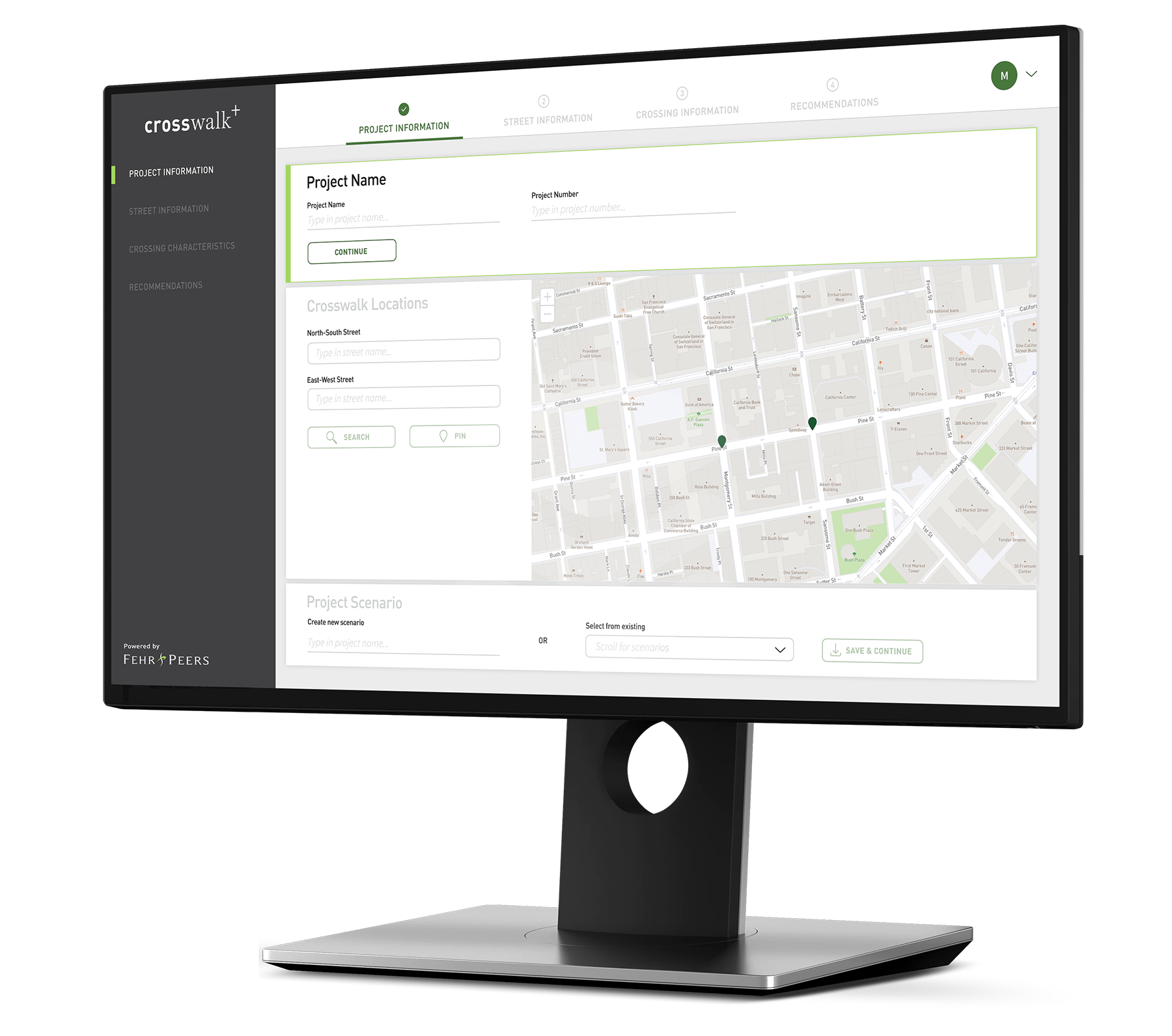
Fehr & Peers is actively enhancing our current CrossWalk+ tool — incorporating GIS and bringing it web-based. CrossWalk+ integrates with the most recent safety research from a variety of sources to quickly assess effective countermeasures and operational enhancements to improve pedestrian safety. CrossWalk+ offers communities guidance on potential crossing safety solutions for large-scale projects with variable roadway characteristics, controls, and contexts. Using CrossWalk+ provides four key advantages over a more static recommendation process, including the ability to:
Customize
The tool can be updated for new methodologies and potential crossing treatments and customized by jurisdictions to account for local design guidelines.
Streamline
Imported GIS data on crosswalks and surrounding built environments can be streamlined to proactively identify potential challenges and recommend enhancements.
Compare
Multiple locations and scenarios can be evaluated at once by uploading and/or entering data for each location or obtaining data from GIS layers.
Visualize
Geodesign and analysis for visualization of recommended treatments with links to similar real-world examples.
The underlying CrossWalk+ analysis process can be applied to corridor studies, pedestrian master plans, and as was recently developed for Alameda County, California, comprehensive crosswalk policies. By integrating recommendations from CrossWalk+ as a standalone crosswalk policy, Alameda County was able to implement national best practices while ensuring the processes addressed local needs and worked toward achieving locally-desired outcomes related to quality of life.
Supporting Safer Crossings in…
Alameda County, CA
Alameda County serves a diverse range of communities with unique characteristics and needs, from predominantly rural settings with few pedestrians to urban environments with heavily-congested streets. We created a standardized process and associated tool for consistent installation of crosswalk treatments, signalized intersection treatments, and crossing guard assignment throughout Alameda County. This policy needed to be flexible enough to accommodate differences between rural, suburban, and urban environments, while still being grounded in the most rigorous safety efficacy research.
By integrating the research and recommendation process of Xwalk+ into a standalone crosswalk policy, Fehr & Peers helped Alameda County put pedestrian safety considerations into the basic decision-making process for all roadway improvement projects. Using this policy framework, Alameda County was able to implement national best practices while ensuring that decision-making processes fit local needs.
Denver, CO
The City of Denver is constantly looking for ways to improve safety and infrastructure for all users. One recent initiative from the City is to develop “Action Packets” that collect and analyze operational, physical, and safety characteristics to identify improvements for priority locations. Fehr & Peers will initiate preliminary engineering drawings for implementable and locally-supported strategies that address crossings, green infrastructure, sidewalks, lighting, intersection geometry, curb ramps, and ADA-compliance and accessibility. This effort also includes a focus on monitoring, data collection, speed studies, and evaluation to understand how the projects are functioning for the community.
Honolulu, HI
As part of effort to develop a Pedestrian Plan for Honolulu, Fehr & Peers is developing unsignalized crosswalk best practices and a crosswalk tool that incorporates a decision-making process for installing signalized pedestrian crossing treatments, including exclusive pedestrian phases, leading pedestrian intervals, and no right turn on red (RTOR). These treatments can be helpful in enhancing the safety of pedestrian and vehicle interactions, particularly at crossings, and are only appropriate in circumstances where delay to vehicles can be well-balanced with the convenience of and demand for innovations such as a diagonal crossing option or an advanced pedestrian phase.
We are currently tailoring an approach for Honolulu by conducting best practice interviews with City and County of Honolulu staff and peer agencies to develop and refine a list of constraints for signalized crosswalks. One flowchart will be created for each treatment type, along with a technical memo documenting the associated best practice research. The flowcharts will also offer agency staff guidance and a “first step” on how to incorporate collision history into the decision process (i.e. the types of collision factors to screen for when determining which of these signalized crosswalk enhancements is most applicable).
The process for finalizing the flowcharts will be an iterative process with calibrations and revisions based on pilot testing at intersections to determine if the resulting design decisions reflect the goals of the City and County of Honolulu.
Issaquah, WA
We’re about to kick off two projects with the City of Issaquah in Washington: (1) A Mobility Master Plan, which will establish the City’s 20-year vision for providing multimodal transportation and (2) A Policy and Standards Update, which seeks to modernize and enhance the City’s existing Complete Streets Policy, Pedestrian Crossing Guidelines, and Traffic Calming Program.
Port Orchard, WA
In 2016, we assisted the City of Port Orchard in Washington, in developing a set of Pedestrian Crossing Guidelines that can advise when a crossing should be provided and the types of treatments that would be most appropriate given the adjacent land uses and roadway characteristics.
Puyallup, WA
We’re currently working with the City of Puyallup in Washington, to develop a Safe Routes to School Master Plan, which will identify the highest priority treatments (including sidewalk and trails completions, intersection and crossing enhancements, and traffic calming installations) to make walking and biking to school more welcoming.
National Research & Guidance
FHWA Crossing Guidance
The Federal Highway Administration’s Guide for Improving Pedestrian Safety at Uncontrolled Crossing Locations establishes a multi-step process for assessing which safety countermeasures should be considered at uncontrolled crossings based on the latest broadly applicable safety research. This Guide serves as the underpinnings to Crosswalk+.
ITE Pedestrian Crossings Safety Working Group
The ITE Pedestrian Crossings Safety Working Group is comprised of researchers, public agency staff, as well as private consulting representatives working to identify and promote best practices and needs for implementing safe and consistent pedestrian crossings. Fehr & Peers staff, Ryan McClain and Claude Strayer, lead this group for ITE. 2019 focus areas for the group include creating a how-to guide on crosswalk policies and assembling latent demand data for pedestrian hybrid beacons.
Learn more by contacting one of our industry experts.
Quick Links
© 2017 – 2024 Fehr & Peers. All rights reserved.