Leveraging New Technology & Mobility Services
Practical Guidance
Oregon Metro’s Approach to Considering Mobility Solutions for All Residents
As seen at Urbanism Next 2021
Mobility gaps, or barriers in a user’s ability to complete a trip, are quite common. The good news is that there are many ways to fill those gaps and connect people with convenient, affordable travel options to help them access the services they need. However, an area as large as the Portland region presents one of the most difficult problems: understanding where an agency should focus its time, money, and effort to be most effective in filling those gaps. For an agency like Oregon Metro, with a clear and stated focus on meeting the needs of historically marginalized communities, these decisions cannot be made without also looking at the people living in each area and understanding their specific mobility needs.
In a recent partnership with Oregon Metro and as part of the agency’s Emerging Technology Implementation Plan, Fehr & Peers conducted a three-part assessment to identify ideal areas for implementing emerging technology pilot programs at both the regional and local levels.
Equity Assessment
Identify candidate neighborhoods and communities within the Metro region with a relatively high need of equitable access to transportation
Suitability Assessment
Determine where specific technology-enabled mobility solutions could be leveraged to fill mobility gaps at a regional and local level
Blended Analysis
Determine how these equity and suitability assessments could work together to more practically apply new technologies in a way that serves all
Equity Assessment
Key questions
Where are the clusters of historically marginalized communities (HMCs) and other vulnerable populations in the Metro region?
Where are there gaps in mobility services?
Where are the hotspots with a high concentration of HMCs and vulnerable populations with the highest need for mobility options and services other than a personal automobile?
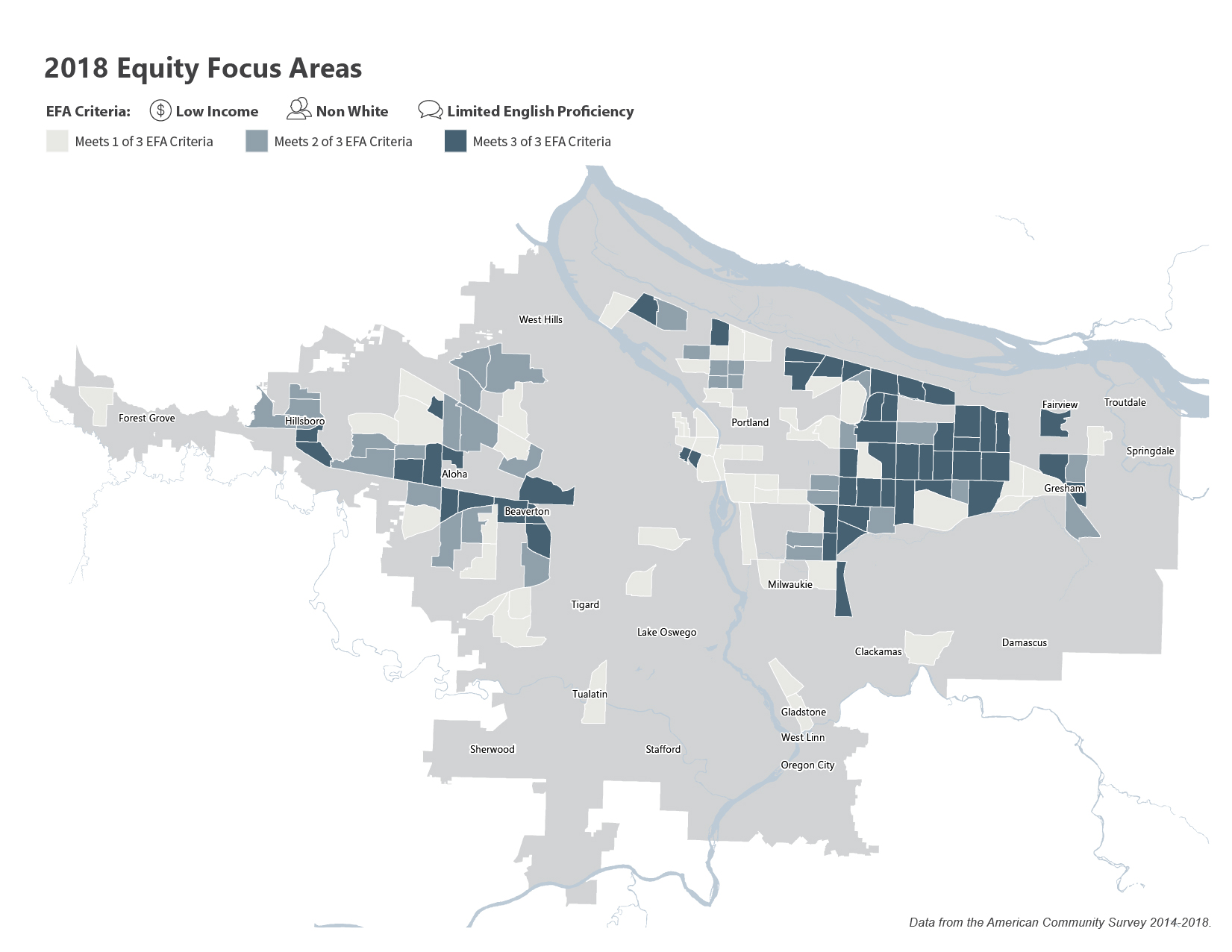
Metro previously established a methodology for identifying Equity Focus Areas (EFAs), which are census tracts with high concentrations of low-income, non-White, and limited English proficiency populations. We started with these EFAs and also identified areas of the region with high concentrations of those over 65, those under 18, households without a vehicle, and individuals with a disability.
The map identifies areas that met one, two, and all three EFAs, providing a necessary perspective on vulnerable populations when recommending effective areas for emerging technology deployment opportunities.
Suitability Assessment
Key Questions
What areas are likely to be considered suitable for implementing emerging technologies based on how the land is used, key local destinations, and how the nearby transportation network is currently connected?
What areas are most likely to benefit from deploying technology-enabled mobility services?
We began by identifying areas within the region which represented the greatest potential to support the following five mobility options:
Conventional Bikeshare
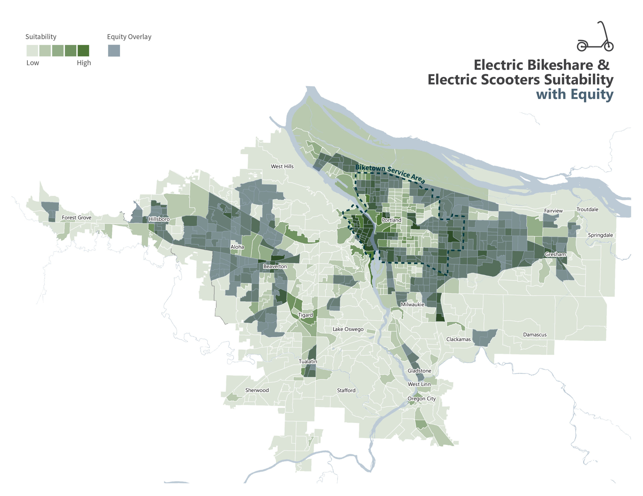
Electric Bikeshare & Scooters
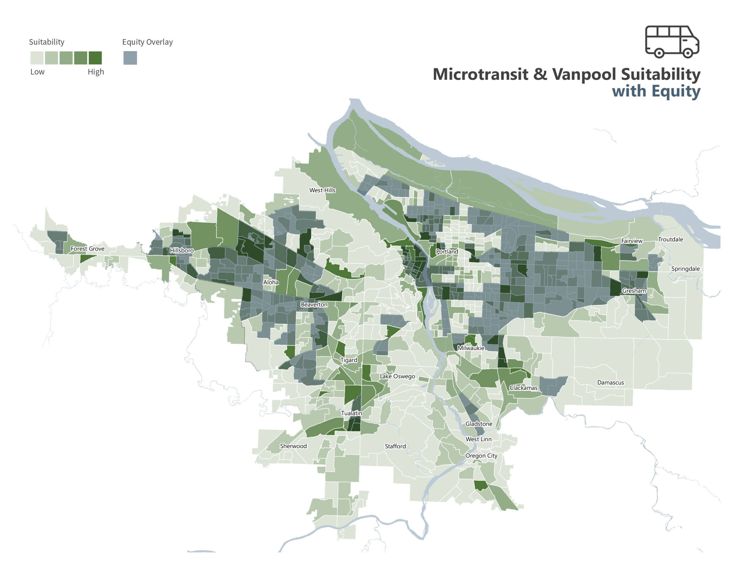
Microtransit & Vanpool
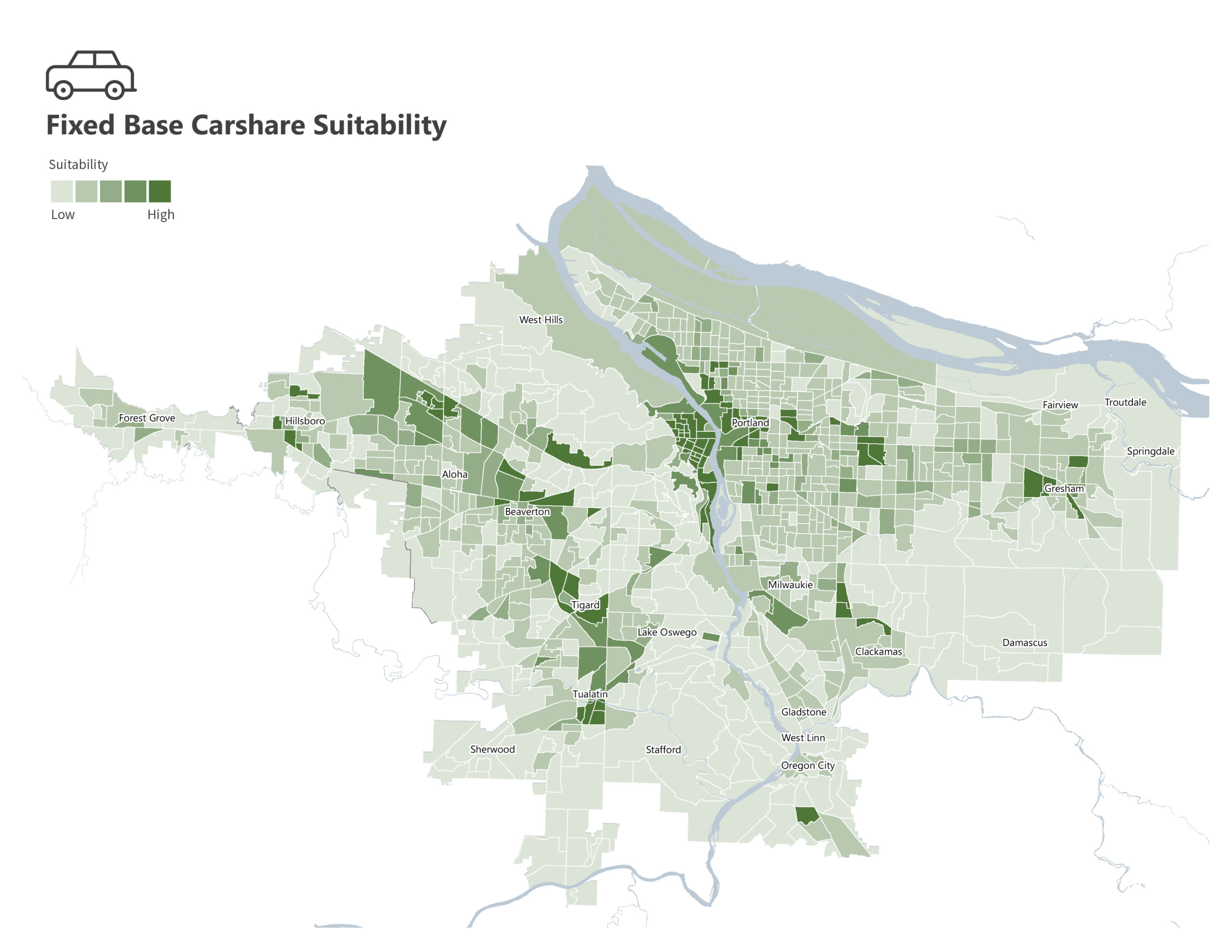
Fixed-Base Carshare
Ridehailing
Each new mobility technology possesses unique needs and constraints, prompting the need to identify factors that are the most important in determining if the option could be suitable for filling a gap in an area. After analyzing multiple sources of spatial data (land-use data, availability of transportation options, density, physical barriers, and opportunities/constraints) with existing infrastructure, we developed a list of five to eight factors that were most significant in influencing the need to fill mobility gaps. Individual weighting was assigned to each factor. Then, we identified several neighborhoods and communities within the Metro region scoring relatively high on those factors.
More about suitability Methodology
The region’s market suitability was assessed for each block group in three ways:
- Origin/destination land uses such as:
- Key destinations including but not limited to hospitals, schools, libraries, parks, community centers, and park-and-rides.
- Land Use/Zoning
- Areas with slope >4%
- Average trip lengths as determined by travel model data
- Population and employment density
- Network characteristics that would support the new service such as:
- Sidewalks
- Percentage of streets with sidewalks on one or both sides
- Connectivity for each block group as a percentage of a perfect grid
- Bike Facilities
- Miles of the planned bicycle network completed
- Bike connectivity
- Transit
- The proximity of each block group to a frequent transit stop
- Bike share
- Percentage of the block group in the current Biketown service area
- Sidewalks
Blended Analysis: Prioritizing Next Steps
With a widespread suitability assessment for each option, the equity mapping was overlaid on top of the newly identified neighborhoods suitable for emerging technology deployment. When equity mapping is considered with a suitability assessment, areas of both high suitability and high equity needs are discovered.
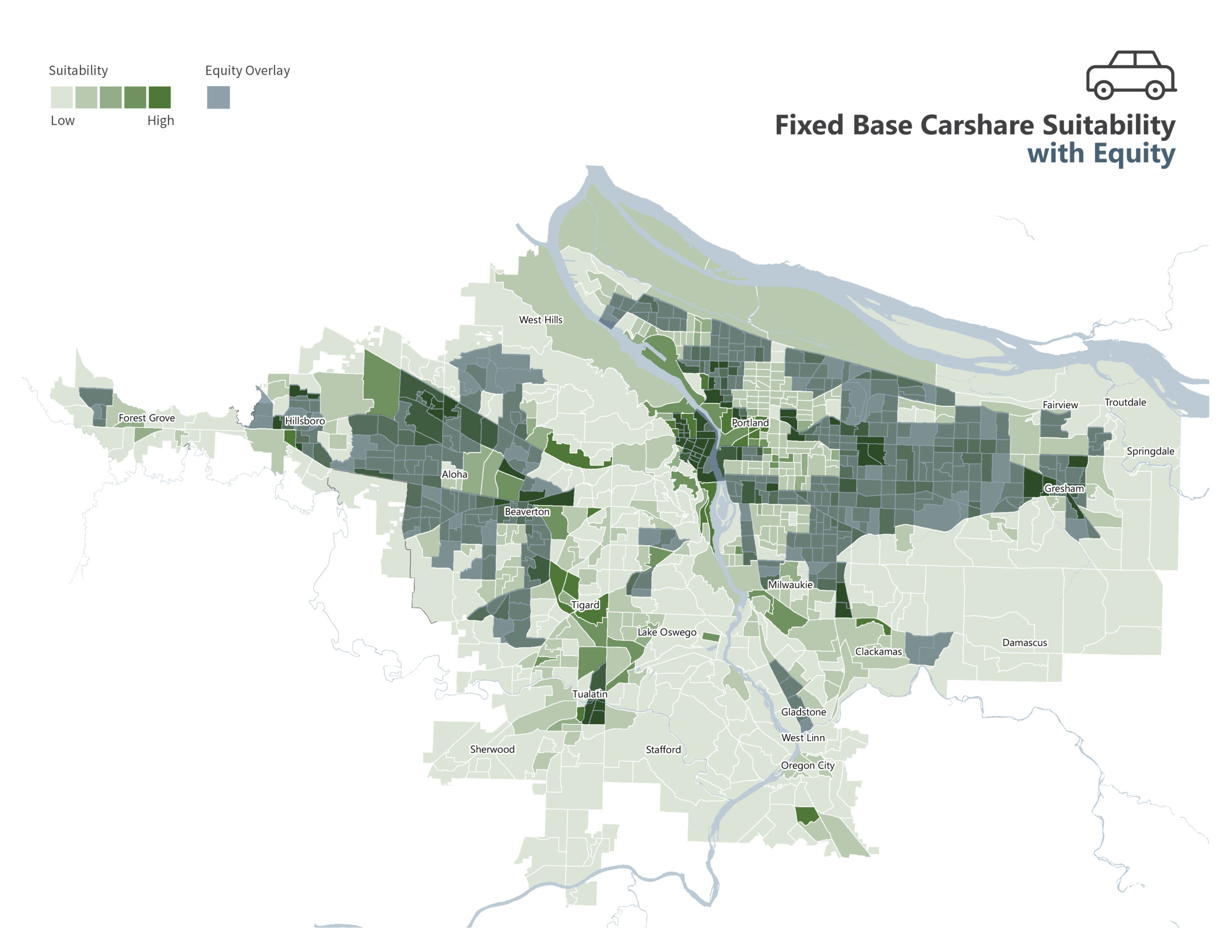
All areas of the region were grouped into one of four different typologies:
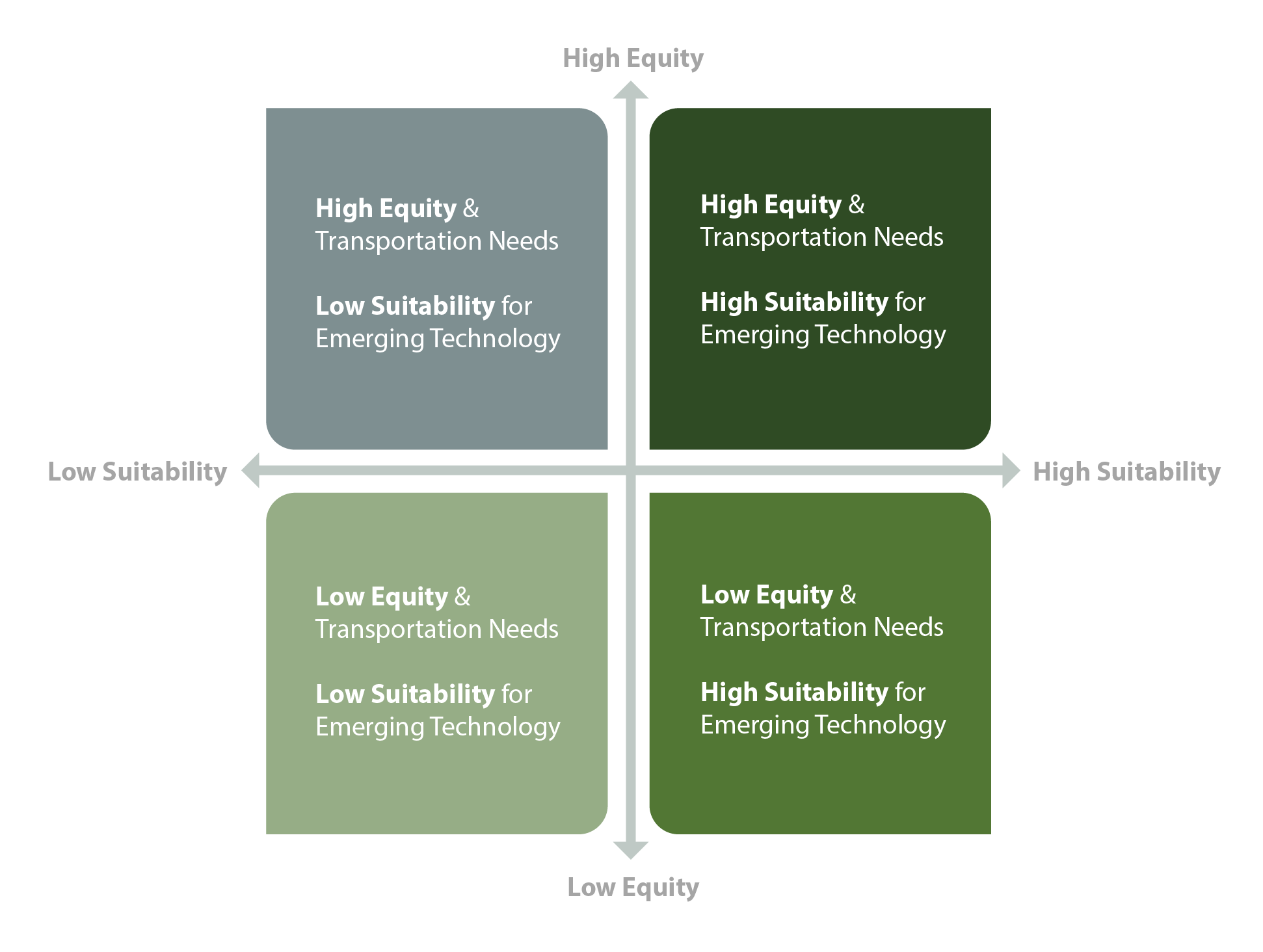

High Equity + High Suitability
Priority locations for which new transportation choices could be economically viable and serve people needing them most

High Equity + Low Suitability
Not likely to be market-driven, requiring subsidies or other mechanisms to provide mobility solutions

Low Equity + High Suitability
Likely attractive to providers, and the focus will be on managing these providers and services

Low Equity + Low Suitability
Lower priority for emerging technology programs but could be monitored for future changes
Metro now has a blended assessment, allowing the agency to strategically focus time, energy, and budget on the areas of the region with the greatest needs and potential for implementing new technologies to fill mobility gaps.
Curious to learn or talk more about this study?

