
Level of Traffic Stress
Balancing LTS Accuracy & Cost
Increasingly, whether in emerging arenas such as micromobility or general bicycling activity, we are seeing that the comfort of facility users is related to the quality and perceived safety provided by the facility. One prominent metric that is used to assess network quality and accessibility is Level of Traffic Stress (LTS), but the cost of compiling the necessary data to calculate LTS over a citywide network can be prohibitive. This combined with data inconsistencies from jurisdiction to jurisdiction make comparative analysis at a county or regional scale even more challenging.
Open Street Maps (OSM) has the potential to cost effectively fill the data gap for agencies without detailed geospatial data, but the challenge is finding the right balance between accuracy and cost. In a recent research effort we compared OSM-derived LTS scores against “ground-truthed” scores from Montgomery County, Maryland and identified strategies to improve accuracy.
Montgomery County’s Ground-truthed LTS Network
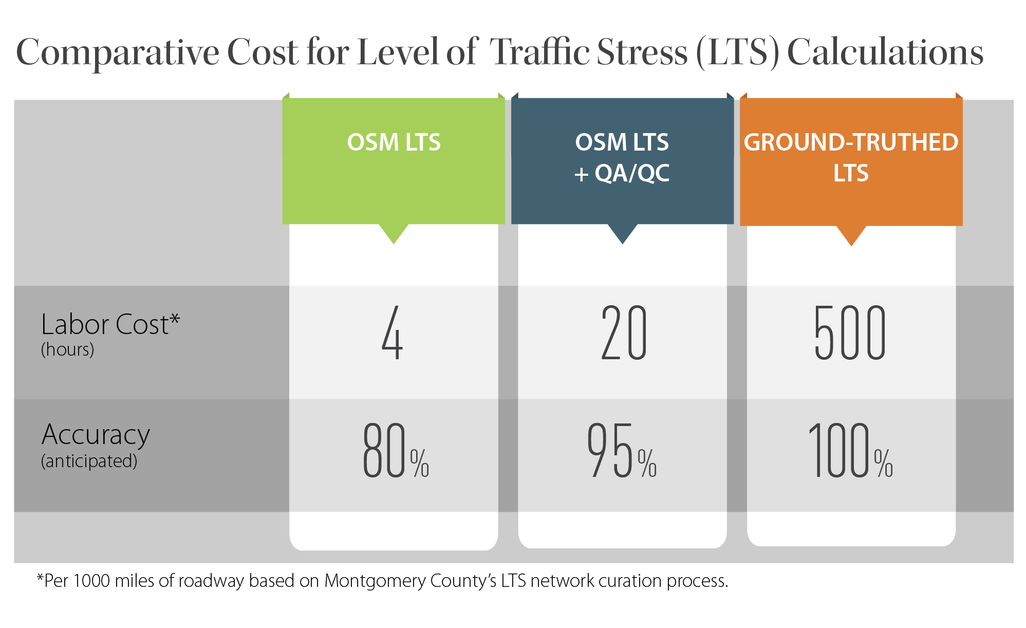
Montgomery County developed a ground-truthed LTS network by field checking roadway conditions to ensure accuracy. Our findings to the left show that OSM-based LTS calculations, when combined with strategic QA/QC efforts, targeting roadway categories and land use conditions known to have higher error rates, can achieve comparable levels of accuracy at a fraction of the cost. The theoretical accuracy rates approach 95% for less than 5% of the effort needed to develop a fully ground-truthed network.
Mispredictions
We found the highest misprediction rates occurred on facilities classified in OSM as collectors or minor arterials and in areas with lower population and employment densities.


Discrepancies
Our comparative accessibility analysis demonstrated that while the two networks can provide roughly comparable results at the segment level, a small number of mislabeled segments can lead to larger discrepancies at the route level.
Others have identified LTS proxies from OSM such as Conveyal and PeopleForBikes. These works illustrate the value of a common database such as OSM to generate scalable metrics across regions, but the crowd-sourced nature of OSM brings into question the quality of these network assessments. However, our quantitative analysis of OSM-derived LTS metrics now provides cities and transportation professionals with targeted quality control and assurance strategies that offer reasonable accuracy with significant cost savings over ground-truthed analysis. Our research suggests focusing QA/QC efforts on:
- Roadway segments with “secondary,” “tertiary,” “track,” and “unclassified” tags;
- areas with very low or high population or job densities; and
- on corridors that are known to be critical to the network being analyzed.
Learn more by contacting one of our industry experts.
Quick Links
© 2017 – 2024 Fehr & Peers. All rights reserved.