
Evacuation Travel Time Analysis
Addressing Evolving CEQA Analysis Needs
A series of recent California Environmental Quality Act (CEQA) lawsuits related to emergency evacuation analysis has established an emerging need for quantitative evaluations of evacuation routes and travel times to be included in project-level CEQA analyses.
Section 15151 of the CEQA Guidelines requires that Environmental Impact Reports (EIRs) represent “a good faith effort at full disclosure” of environmental impacts. EIRs, however, are frequently challenged in court on the basis of an analysis not adequately studying environmental impacts including the impact of the environment on human activity and life safety.
Recent wildfire history in California has shown that the ability to evacuate a hazard area has substantial life safety implications. Realizing this in the Guenoc Valley court case in Lake County, a judge invalidated a certified EIR lacking an evacuation route analysis because “there is evidence that the project might exacerbate existing environmental hazards” and “the hazards of a wildfire are certainly exacerbated if community residents are unable to evacuate safely due to congested evacuation routes.” Other decisions in Placer County and San Diego County affirm that a quantitative analysis of evacuation routes and travel times is required to provide “a good faith effort” at the full disclosure of impacts as required by CEQA.
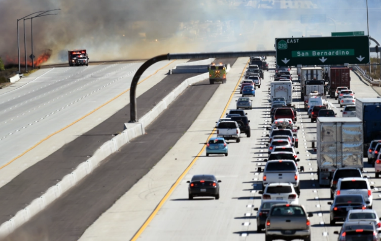
Evacuation events create travel demand conditions that result in substantially atypical congestion patterns and travel times.
These rulings have emphasized the need for CEQA transportation analyses to fully consider the implications of projects in high wildfire areas that may experience the need to evacuate. The courts have also affirmed that substantial evidence must be provided to support any evacuation significance conclusion and that the evidence should include an evaluation of whether evacuation of persons in adjacent areas would be affected by evacuation of a project’s residents during a wildfire. In addition to court cases and decisions, the CEQA process on this topic is informed by guidance from the State Office of Planning and Research (OPR) and their recently updated Technical Advisory on fire hazard planning; the Attorney General’s office is expected to release new guidance on the topic in the near future.
Considerations for Generating Evacuation Roadway System Demand
Forecasting for evacuation trip demands is complex due to the broad range of evacuation conditions that may need to be considered. In many cases, data for these topics is not available from traditional sources of travel demand information. Travel demand for evacuation scenarios varies heavily on the time of day, automobile availability, route options, fire behavior, and the locations of evacuation shelters and/or hotel facilities.
For example, an overnight evacuation scenario would generally reflect a household occupancy approaching 100%, few residents at work or school, and daytime visitor demand at a low. On the other hand, an evacuation occurring at 5:00 PM on a weekday would result in a mixing of heavy background traffic demand due to some residents returning home from work, some residents already being at home, some workers returning home before evacuating, and visitors evacuating to different destinations than residents. This combined with the potential for some households to choose to evacuate as many vehicles as they have drivers (e.g., a two-person household evacuating in two vehicles rather than one), makes evacuation vehicle demand highly variable based on time-of-day, land use, and other demographic information.
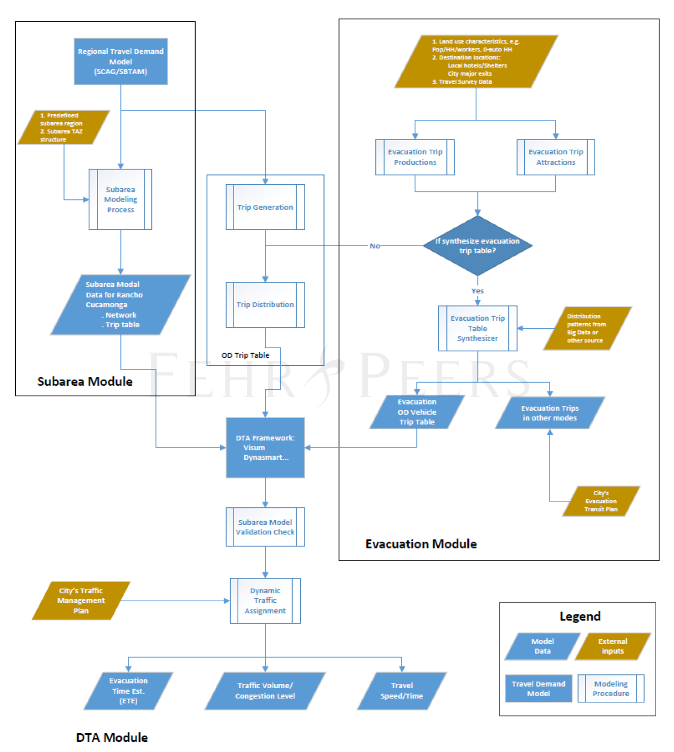
Conceptualized evacuation analysis framework using data from the travel demand model and a Dynamic Traffic Assignment operations model.
Travel demand models are built and maintained to address travel demand on a typical weekday, whereas evacuation conditions result in abnormal travel patterns and traffic operating conditions. One potential evidence-based technical approach would consider census data and relevant data from the local travel demand model (land use information, roadway network information, etc.) to estimate vehicle trips during an evacuation scenario. The demand analysis should also consider locations of evacuation shelters and the level of background traffic, along with assumptions of when people will evacuate and where they will go. After demand estimation is completed, it is critical to estimate how congestion accumulates during an event to better understand how queues and congestion affect travel time behavior. It is noted that travel demand models alone cannot accurately reflect and predict evacuation times due to their insensitivity to how queues build over space and time.
Developing Evidence-Based Study Scenarios
The transportation industry’s response to this new area of CEQA analysis should rely upon the development of scenarios that (1) consider historical wildfire evacuation events and patterns and (2) incorporate expert opinions such as those from local fire and law enforcement personnel – provided those expert opinions are supported by substantial evidence as required by CEQA. An infinite number of potential evacuation scenarios exist, from evacuations with advance notice to worst-case scenarios where large areas must evacuate immediately with limited notice (particularly relevant in areas with a history of firestorm behavior). Leveraging historical wildfire experience and expert opinions helps to focus the analysis on those that are most in-line with the requirement to disclose CEQA impacts for the public, or how a project would affect the surrounding community in terms of the change in its ability to evacuate.
Leveraging the State of the Practice to Inform Analysis Methods
Currently, there is limited case law and no standard technical guidance (as of August 2022) defining a technical method of analysis that would be sufficient to demonstrate “a good faith effort” at the full disclosure of impacts because this is an evolving area of CEQA practice. As such, the state-of-the-practice” should inform which analysis options are most reasonable to deploy. In non-evacuation corridor travel time estimate analyses, the state of the practice would suggest that travel demand data (from a travel demand model or other sources) be input into a traffic operations analysis software designed to consider Highway Capacity Manual (HCM) methodologies to estimate typical delays to the transportation network. The HCM notes that in supersaturated/congested conditions, such as an evacuation event, a simulation model should be used to estimate operating conditions and how congestion can affect travel times.
Given the network effects of an evacuation, a meso-scale or micro-scale operations analysis could be used to estimate operating conditions and generate evacuation travel time estimates. More macro-scale evaluations, such as using regional travel demand models, can be modified to estimate very high travel demand forecasts, but should not be used to produce specific travel times during congested conditions. For non-evacuation analysis, travel time information from big data sources shows that travel demand models can underestimate travel times along typically congested corridors by 50%-100% because travel demand models are not designed to estimate the physical extent of congestion and their compounding effects on travel times. This suggests that under supersaturated conditions, such as an evacuation event, travel demand models could further underestimate travel times.
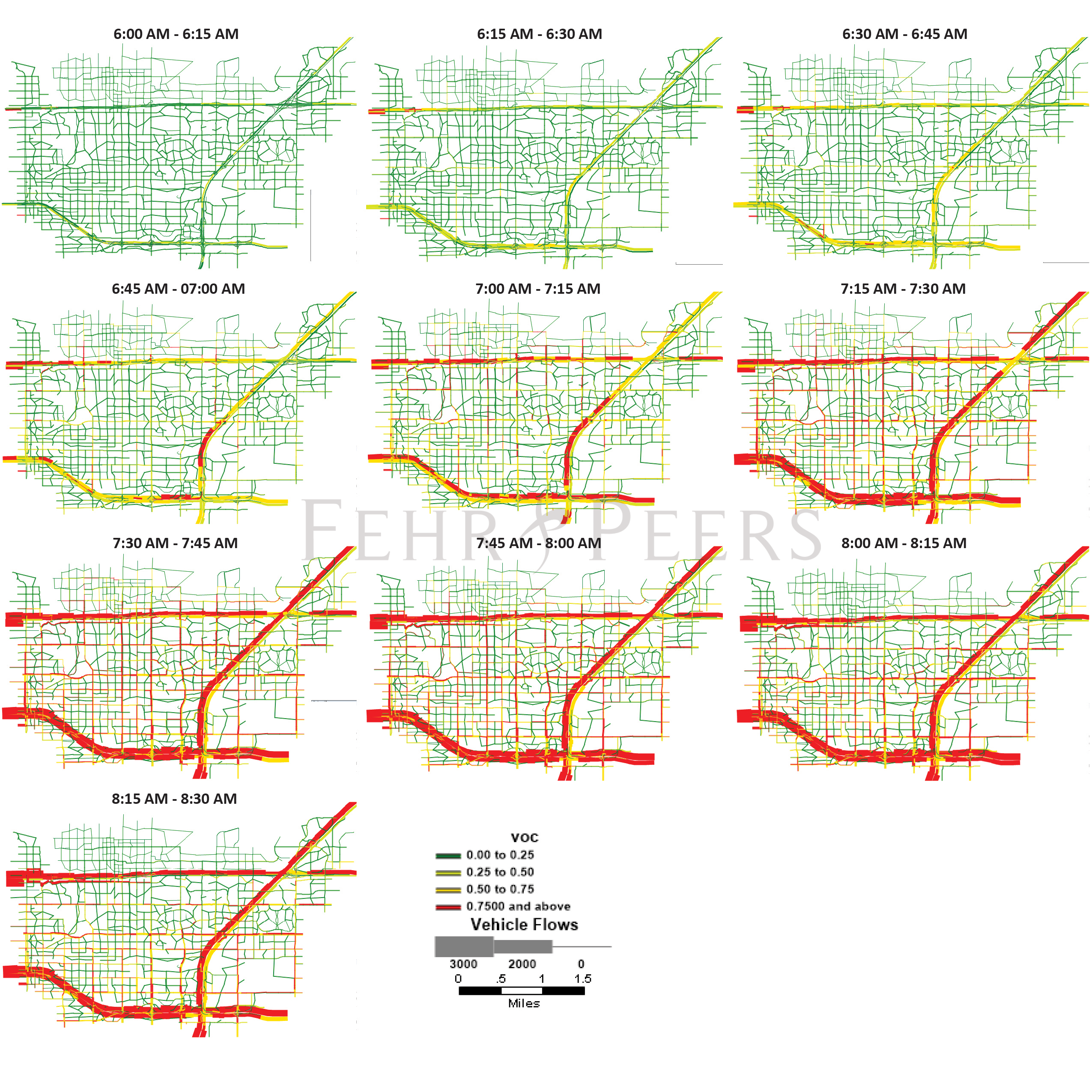
Dynamic Traffic Assignment (DTA) and other operations models allow for the tracking of the physical and temporal extents of congestion over multiple time periods (e.g., hours) in ways that travel demand models alone are unable to do.
Dynamic Traffic Assignment (DTA) models, a meso-level model, can leverage uncongested speed and link-level capacity data from the local travel demand model and track the physical and temporal lengths of congestion (e.g., how queues build over space and time) relative to evacuation demand. Evacuation time estimates generated from this analysis approach are consistent with the state-of-the-practice and may satisfy CEQA’s “good faith effort” requirements. Other traffic operations software packages could be used to estimate delays and travel times. The key is to choose a traffic operations analysis methodology that fits the congestion context of the project vicinity.
What’s Next on the Horizon of Evacuation Analysis?
The preceding information is based on Fehr & Peers’ research into the methods and tools available to respond to the Guenoc Valley decision and the need to provide a quantified analysis of evacuation times as part of a project-level CEQA analysis. While there is much left to be decided by the courts on the topic, we understand that the State Attorney General’s office will be releasing new guidelines in the coming weeks. Ultimately, practitioners should continue to apply state-of-the-practice methods to evaluate CEQA impacts in this evolving space including the use of traffic operations analysis software packages to evaluate travel times (as recommended under the Placer County decision) to disclose project impacts to the public.
For more on the tools that Fehr & Peers has developed, including the Evac+ model that incorporates evacuation demand estimation best practices and a DTA model for traffic operations, please see this link: Evacuation Planning and Resiliency.
Interested in learning more about Evacuation Analysis?